CCR Gallery

Photos from users of myccr.com
Home > Canoe Routes > Ontario
Click to view full size image

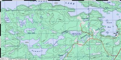
Approach to Dunlop Lake from the south

possible, but not sure: launch at Marsh, paddle through Summers and reach Dunlop via Green. The new developments on Dunlop's shore may prevent the last portage.
But the road that approaches Marsh serves the south shore of Dunlop and thus probably runs along most of that lake.

DSCN01230058_S.jpg DSCN4899.JPG DSCN4912.JPG Dunlop_Lake_South_Aproach.jpg Dunlop_Loop_S-small.jpg English Fishery Harbour.jpg Evening2.JPG
File information
Filename:Dunlop_Lake_South_Aproach.jpg
Album name:erhard / Ontario
Rating (1 votes):00000(Show details)
Filesize:65 KiB
Date added:Aug 13, 2008
Dimensions:636 x 316 pixels
Displayed:737 times
EXIF Image Height:316 pixels
Resolution Unit:Inch
Y Resolution:72 dots per ResolutionUnit
YCbCrPositioning:Center of Pixel Array
URL:http://gallery.myccr.com/displayimage.php?pid=1793
Favorites:Add to Favorites