Home
Login
CCR Gallery
Photos from users of myccr.com
MyCCR Home Page
Album list
Last uploads
Last comments
Most viewed
Top rated
My Favorites
Search
Home
>
Canoe Routes
>
Quebec
FILE 203/1380
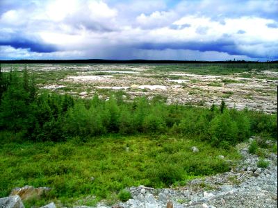
Dry Caniapiscau Riverbed
Dry riverbed of once mightly Caniapiscau River (it used to be one of the largest Quebec rivers) below the Caniapiscau Reservoir Dam.
File information
Filename:
0214LC_Dry_Caniapiscau_riverbed.jpg
Album name:
lllynette
/
Quebec
Rating (1 votes):
(
Show details
)
Keywords:
Caniapiscau
Photo Credit:
Lynette Chubb
Date:
July 28, 2007
Place Taken:
54:49:50.07 N 69:51:6.88 W
Route Name:
Caniapiscau
Filesize:
363 KiB
Date added:
Feb 15, 2008
Dimensions:
1600 x 1200 pixels
Displayed:
1094 times
Digital Zoom Ratio:
0
EXIF Image Height:
1200 pixels
FlashPix Version:
version 1
ISO:
64
Resolution Unit:
Inch
Saturation:
0
Y Resolution:
72 dots per ResolutionUnit
YCbCrPositioning:
Datum Point
URL:
http://gallery.myccr.com/displayimage.php?pid=1538
Favorites:
Add to Favorites